Sunday 25 October 2015

Evapotranspiration stealing the blue water


I want to start, by referring to my first blog post, with map number 2 showing the intrinsic variability in rainfall across the African continent. We can distinguish different patterns of seasonality, ranging from highly seasonal rainfall in arid environments (e.g. Sudan) to seasonally humid environments with most months experiencing precipitation (e.g. Malawi).
Adding to the annual rainfall variability, it is also important to acknowledge the year-to-year rainfall variability in Africa, and the rainfall variability within a certain period of year (especially onset of wet season).
Blue water resources: renewable freshwater resources, such as river discharge of a permanent river.
I want to extrapolate the occurrence of “blue water resources” on this rainfall variability by examining the influence of evapotranspiration at present and under climate change.
Blue water resources are only possible to be formed when the rainfall exceeds the evapotranspiration – thus, in all African regions, only certain months of the year contribute to their maintenance. In the tropical regions and the Sahel, temperatures throughout the year are relatively warm and stable and therefore potential evapotranspiration rates do not vary as greatly as in higher latitudes (temperate climates). Rainfall, however, as I have outlined previously, varies greatly in its distribution and sums.
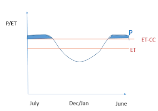
Sudan’s mean rainfall throughout the year never significantly exceeds the constant evapotranspiration (ET) loss threshold and this explains the lack of blue water in the Sahel.  A warming planet, and the resulting rise in potential evapotranspiration will only increase this threshold further, and reduce the number of years (and months in a year) rainfall exceeds this.
It is interesting to show the potential of a rise in this ET threshold on regions with blue water resources, such as in the seasonally humid tropics of Africa. For simplicity, and due to the uncertainty of GCM model output in predicting future rainfall, the precipitation pattern is left unchanged. In the diagrams below, the shaded blue area represents potential renewable freshwater resources at present (ET) and under rising temperatures (ET-CC).


With only a slight rise in evapotranspiration throughout the hydrological year, we see a dramatic reduction of potential freshwater resources, even if the annual rainfall is not altered.


Tuesday 20 October 2015

ITCZ - what do you do?

Africa has the largest landmass of all continents around the equator and extents from Tunisia at 37°21′ N to Cape Alghulas in South Africa at 34°51′15″ S. Climate is largely determined by latitude – and in particular a locations position in relation to the moving Intertropical Convergence Zone (ITCZ). Rainfall follows the ITCZ, leaving the areas adjacent to it dry (see role of Hadley cells in distribution of rainfall here) and generally explains the humid tropic climates, and (semi-) arid climates of the subtropics.
However, the ITCZ does not remain in place. Over a year, the zone moves north and south following the Sun’s zenith point on Earth. The movement is more subtle over the oceans, more defined over land-masses like Africa. Please follow the link to a visualisation of the annual ITCZ migration. As clearly shown, regions located between the northernest and southernest location experience rainfall in much of the year, whereas higher latitude locations will only ‘get in touch’ with the ITCZ once a year. This explains the 1) rainfall variability throughout the average year and 2) rainfall variability between different latitude locations. For more maps, see my introductory post please!

Thursday 15 October 2015

The Intro - and an overview of current and predicted rainfall patterns

Hello everyone!
Following my interest in future climate change impacts on the planet and the sustainability of water use under these changing influences, I want to dedicate this blog to explore the impacts of environmental change upon Africa’s water. The continent is exceptionally interesting to study due to its diverse spatial distribution of  water and the variety in access to and usage of it.

As Conway et. al. (2009) clearly portray in their examination of rainfall-runoff relationships in catchments of Sub-Saharan Africa, rainfall is the dominant control on interannual and interdecadal variability of river flows and thus renewable surface freshwater distribution. To examine the effect climate change has upon water resources in Africa, I will start my blog by focusing attention on current precipitation patterns.

The two maps below give a good overview of how rainfall varies between and within regions, mainly depending on latitude, season, topography, distance to/from the sea and, of course, global climate circulations. These current patterns give a first indication of the spatial and temporal (see map 2 for annual variability) diversity of renewable surface water flows. Africa's populations and environments are generally highly adapted to the unique local circumstances. However, with predicted anthropogenic climate change, the vulnerability of some areas to change in precipitation is great.


IPCC model predictions (2014) on region-specific future precipitation changes (i.e. frequencies of droughts or flooding) are at most of "medium confidence", however we must note the widely acknowledged ‘intensificationof the hydrological cycle’ in a warming world. This means that even with a relatively unchanged spatial distribution of water, current patterns of precipitation variability (temporal distribution) will increase. Through the course of my blogging I will review detailed climate change impact-studies that reflect this predicted change in rainfall patterns, as well as investigate the varying risk of extreme events like droughts and floods (Thornton et. al. 2014 for a comprehensive overview).